HMDA Master Plan 2031: Zones, Map & What It Means for Hyderabad Home Buyers (2026)
If you or someone you know is looking for flats/apartments or villas in Hyderabad, there’s one term you’d likely come across — HMDA Master Plan 2031. To a lot of home buyers or for those planning to purchase a property, it sounds like a document from a government plan that only architects, builders or urban planners need to understand. In fact, it is one of the most important documents that will decide the future value, legality and liveability of your property.
The HMDA Master Plan can impact if you are planning to buy a flat in Kokapet, a villa in Shadnagar or a plot near Adibatla, in the following ways:
- Is construction permitted in the area
- Future infrastructure development
- Road connectivity
- Property appreciation potential
- Availability of civic amenities
- Bank loan eligibility
- Long-term investment security
In conclusion, the answer to an essential query every buyer faces will be addressed by the master plan:
What will my property be worth in ten to twenty years?
There will be an assessment of the HMDA Master Plan 2031, including information regarding the various land use zones to include in the plan as well as descriptions of all areas included within the plan; describe how the two different layouts compare; and provide guidance for confirming zoning prior to purchasing property.
Be Among the First to Own a Legacy
What Flat Buyers Must Know About HMDA Master Plan 2031 & Why It Matters?
HMDA Master Plan 2031 is the long-term urban development plan prepared by the Hyderabad Metropolitan Development Authority (HMDA).
Its objective is to direct the planned growth of Hyderabad Metropolitan Region and balance:he planned growth of the Hyderabad Metropolitan Region while balancing:
- Residential development
- Commercial activity
- Industrial expansion
- Transportation infrastructure
- Environmental protection
- Public amenities
When we think about building homes we have to follow a master plan. This plan says what can be built and where. It does not let people build anything anywhere.(Source)
For people who want to buy a home the master plan is important because it decides:
What Can Be Built
The plan does not allow homes to be built on every piece of land. Some land is not meant for homes.
Some areas may be reserved for:
- Agriculture
- Industrial activity
- Public infrastructure
- Environmental conservation
Buying property without checking the zoning classification can create problems later.
Future Infrastructure
The master plan identifies future:
- Roads
- Transit corridors
- Growth centres
- Economic hubs
Properties that are located in areas where a lot of growth is expected often go up in value over time.
Legal Compliance
Projects that follow the rules and regulations of the area usually have problems, with approvals and meeting the requirements.
Property Value Protection
When development follows a planned framework, neighbourhoods generally enjoy:
- Better infrastructure
- More organised growth
- Stronger buyer demand
- Higher long-term value retention
For apartment buyers, understanding the master plan is not about urban planning theory. It is about reducing risk and making a more informed purchase decision.
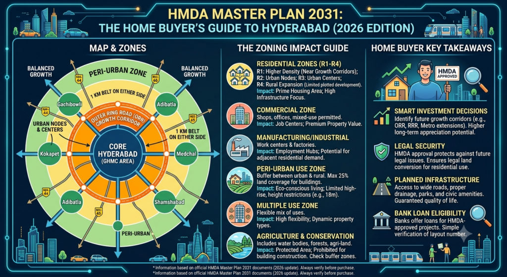
How the HMDA Master Plan Divides Hyderabad,The 12 Land-Use Zones Explained
One of the most searched aspects is the zoning structure of the HMDA Master Plan 2031.
The plan divides the Hyderabad Metropolitan Region into various land use categories and each category has specifications on what type of development is permitted.
The establishment of these districts will aid in the planned development of new residential community areas, industrial developments, public infrastructure developments and environmentally sensitive areas throughout the region.
1.) Residential Districts (R1-R4)
The main areas of residential growth are as follows.
They accommodate:
- Apartments
- Villas
- Gated communities
- Residential layouts
Most apartment buyers will purchase properties located within residential zones.
2. Commercial Zones
These areas are intended for:
- Office buildings
- Retail centres
- Shopping complexes
- Business districts
Commercial zoning has worked very well for places like Gachibowli and the Financial District.
3. Manufacturing and Industrial Zones
These zones support:
- Factories
- Warehouses
- Industrial parks
- Manufacturing units
Residential development is generally restricted or regulated in such areas.
4. Public and Semi-Public Zones
These zones are reserved for:
- Educational institutions
- Government offices
- Hospitals
- Public facilities
5. Recreational Zones
These areas accommodate:
- Parks
- Sports facilities
- Open spaces
- Leisure infrastructure
6. Transportation and Communication Zones
These support:
- Roads
- Highways
- Transport terminals
- Logistics infrastructure
7. Agricultural Zones
Agricultural land is preserved primarily for farming activities.
Residential construction permissions may be limited.
8. Peri-Urban Zones
These are transitional areas between urban and rural regions.
Development is often regulated more carefully than in established residential zones.
9. Green Belt Zones
Green belts help protect environmental resources and control unplanned urban expansion.
10. Water Body Zones
These protect:
- Lakes
- Reservoirs
- Water channels
- Catchment areas
Construction restrictions are generally stricter near water bodies.
11. Special Development Zones
These may be strategically important growth centres, or planned economic hubs.
12. Conservation and environmentally sensitive areas
These areas are designated for the protection of ecological assets and natural landscapes.
Why Buyers Should Care About Zoning
A property’s location within the correct zone directly affects:
- Building permissions
- Future development rights
- Infrastructure support
- Long-term property values
Before purchasing, buyers should always verify the applicable land-use classification.
Which Areas Does the HMDA Master Plan 2031 Cover?
The Hyderabad Metropolitan Area includes significantly more area than simply what is inside the boundaries of Hyderabad.
The Master Plan incorporates roughly 5,965 square kilometers and includes an array of districts, all municipal entities & growth corridors surrounding the metropolitan Hyderabad area.
Thus some of the principal geographical boundaries of the HMDA Master Plan 2031 include:
Western Growth Belt
- Kokapet
- Financial District
- Gachibowli
- Narsingi
- Puppalaguda
These areas have emerged as Hyderabad’s premium residential and commercial hubs.
Northern Corridor
- Kompally
- Medchal
- Shamirpet
This region continues to attract residential development due to improving connectivity.
Eastern Corridor
- Uppal
- Pocharam
- Ghatkesar
These areas get the advantage of lying in the industrial belt and employment opportunities whic is one of the driving factors for growth.
South-Eastern Corridor
- Adibatla
- Ibrahimpatnam
Investments in aerospace, defence and technology have improved the outlook for long-term growth.
Southern Corridor
- Shamshabad
- Shadnagar
The airport-led growth story continues to drive demand in this region.
Why Such a Large Coverage Area?
The city of Hyderabad is growing outward away from the historic city centre. The master plan outlines future development opportunities and helps shape development prior to uncontrolled growth creating infrastructure issues.
HMDA Master Plan and Real Estate, Which Corridors Benefit Most?
One of the biggest reasons buyers search for the HMDA Master Plan real estate impact is to understand where future growth is likely to occur.
While no master plan can guarantee investment returns, it does indicate which corridors are receiving long-term planning support.
Kokapet and Financial District
These locations continue to benefit from:
- Strong employment growth
- Premium residential demand
- Commercial expansion
- Excellent ORR connectivity
The combination of planned infrastructure and economic activity has made them among Hyderabad’s most sought-after residential markets.
Gachibowli
Gachibowli remains one of Hyderabad’s strongest mixed-use growth corridors because of its concentration of:
- IT companies
- Educational institutions
- Corporate campuses
Narsingi
Narsingi has become a major community on the western corridor where individuals can purchase larger housing options while remaining close to their workplace.
Adibatla
Continued investment in industry and aerospace over time will make Adibatla an area of demand for real estate; in addition, as the infrastructure continues to improve, residential real estate demand is expected to remain steady.
Shadnagar
The continued importance of logistics, warehousing and developing infrastructure within the airport corridor will make Shadnagar an important location for development.ing and infrastructure development have kept the airport corridor on the radar.
The ORR Advantage
The growth pattern of Hyderabad has changed due to the Outer Ring Road.
The HMDA planning approach is a radial-concentric model with development expanding outward through connected growth corridors.
In practical terms, this means areas with strong ORR connectivity often enjoy better long-term infrastructure support than disconnected peripheral locations.
HMDA Layout vs GP Layout , The Difference That Protects Your Investment
Difference between HMDA layouts and GP layouts is one of the few things which creates maximum confusion for property buyers in Hyderabad.
Understanding the difference at an early stage can help preventing expensive mistakes later.
What Is an HMDA Layout?
Layout of HMDA is approved by Hyderabad Metropolitan Development Authority and is as per:
- Zoning regulations
- Road-width requirements
- Civic infrastructure norms
- Planning standards
Approved layouts receive a Layout Permission (LP) number.
What Is a GP Layout?
A GP (Gram Panchayat) layout is associated with approvals issued at the village level.
Many buyers mistakenly assume that a GP layout provides the same level of planning approval as an HMDA layout.
This is not necessarily the case.
Why HMDA Approval Matters
HMDA-approved layouts generally offer:
- Better regulatory compliance
- Higher buyer confidence
- Improved loan eligibility
- Stronger resale prospects
Red Flags Buyers Should Watch For
Be cautious if:
- The LP number is unavailable.
- The seller cannot provide approval documents.
- The project claims approval but does not specify the authority.
- Marketing materials use vague terms such as “near HMDA limits” instead of providing actual approval details.
Verifying approvals before purchase can prevent significant complications later.
How to Check HMDA Zone and Download the Master Plan Map With Survey Numbers
The HMDA Master Plan 2031 map download and HMDA Master Plan 2031 PDF are among many items that buyers frequently inquire about, as they want to confirm that a property is within the allowed zoning area.
The process should be simple.
Step 1: Gather the Property Information
Obtain:
- Survey number
- Village name
- Mandal
- District
These details are typically available in ownership documents.
Step 2: Visit the HMDA Portal
Navigate to the official HMDA planning resources and master plan section.
Step 3: Access Land Use Information
You can utilize existing land-use maps and planning tools in order to determine the zoning classification of the property.
Step 4: Confirm the Zoning
Confirm whether the property falls within:
- Residential zone
- Commercial zone
- Agricultural zone
- Peri-urban zone
- Other designated categories
Step 5: Check Layout Approvals
If purchasing a plot, verify the Layout Permission number and associated approval documentation.
Why Survey Number Verification Matters
Many buyers focus only on the project’s marketing claims.
However, the actual survey number classification provides a far more reliable indication of whether development is aligned with the master plan.
A few minutes of verification can prevent years of legal and financial complications.
HMDA vs RERA — What Each Authority Does and Why You Need Both
Another common buyer question is:
Are HMDA and RERA the same? HMDA and RERA relate to real estate; however, their respective roles do not overlap.
What HMDA Does
HMDA focuses on:
- Urban planning
- Land use regulation
- Infrastructure planning
- Layout approvals
- Development control
HMDA answers:
“Can development happen here?”
What RERA Does
RERA focuses on:
- Consumer protection
- Project registration
- Builder accountability
- Delivery timelines
- Transparency
RERA answers:
“Is the developer following the rules?”
Why Buyers Need Both
A project can be RERA-registered but still face planning issues if land-use approvals are not aligned.
Similarly, a project may be located in an approved area but lack RERA compliance.
The safest purchase is one where:
- The location aligns with HMDA planning regulations.
- The project complies with applicable RERA requirements.
Both checks are essential parts of responsible home buying.
FAQs
1. What is HMDA Master Plan 2031?
The HMDA Master Plan 2031 is a planning document created by Hyderabad Metropolitan Development Authority (HMDA) as an urban development strategy to control population and urban sprawl in the Hyderabad Metropolitan area (6,000 sq km). The plan provides a framework for change of land use across the metropolitan area and provides the basis for developing infrastructure and new developments.
2. What is the number of Zones in HMDA Master Plan? What are they?
There are 12 zones (residential, commercial, industrial, public/recreational, agricultural, peri-urban, greenbelt, transportation, water bodies, special development, and conservation) in HMDA Master Plan.
3. What effect does HMDA Master Plan have on Buyers of Real Estate in Hyderabad?
The HMDA Master Plan 2031 will determine where future developments can occur, which projects will receive approvals from the HMDA, investment in new infrastructure developments, and the long-term potential for growth in property values.
4. What is the difference between an HMDA layout and a GP layout?
An HMDA layout complies with planning regulations and carries a valid Layout Permission number. A GP layout may not provide the same level of regulatory compliance or financing support.
5.How can I check the HMDA master plan zone for a specific survey number?
Buyers can verify zoning through HMDA planning resources using survey numbers, village details, and land-use maps available through official planning portals.