Future City Hyderabad & HMDA Master Plan 2050 Explained
Quick Answer
Future City is taking shape through an established development authority, a separate master-planning exercise and infrastructure projects such as the Ratan Tata Road. However, these developments are at different stages: FCDA is already established, the Future City Master Plan–2047 is being prepared, and HMDA Master Plan 2050 is still under study. Understanding this distinction helps buyers assess the area’s development potential without confusing proposed infrastructure or future zoning with facilities and approvals that already exist.
If a brochure promises land in “Future City under Master Plan 2050,” how much of that sentence do you think rests on an actual government notification?
The honest answer is: only part of it. Future City and Master Plan 2050 often appear together in advertisements, yet they are two separate things. Future City has a real authority, created by a government order in March 2025. Master Plan 2050, on the other hand, remains a planning exercise that has not yet become an official zoning map.
This difference matters a great deal to anyone considering land or a home in the area. A government order that creates an authority does not create a city. Similarly, a consultant’s study does not approve a layout.
For buyers in their 30s to 50s, who often invest family savings in land for the long term, clarity here can prevent costly mistakes. This guide explains what legally exists today, what remains planned, where the Ratan Tata Road stands, and which checks a buyer can make before paying a token.
Live Where You Work | Spacious 3 BHKs in the Heart of the Financial District| Ready to move-in | From ₹1.99 Cr .
FCDA and Master Plan 2050 Are Not the Same Document
Two government orders, both dated 12 March 2025, set the stage. Each one does a different job.
| Future City Development Authority (FCDA) | HMDA Master Plan 2050 | |
|---|---|---|
| Legal basis | G.O.Ms.No.69, under section 3-A of the Telangana Urban Areas (Development) Act, 1975 | Not yet notified; related order G.O.Ms.No.68 only redrew the HMDA region |
| What the order does | Creates a special area development authority for the Future City Area | G.O.Ms.No.68 re-declares the Hyderabad Metropolitan Region under the HMDA Act, 2008 |
| Area covered | 56 revenue villages in 7 mandals, about 765.28 sq km, in Rangareddy district | About 10,472.723 sq km, 1,355 revenue villages, 104 mandals, and 11 districts, up to the Regional Ring Road plus a buffer of up to 2 km |
| Current status | The authority exists and is operational | A boundary order exists, but the 2050 plan does not |
In simple terms, G.O.Ms.No.69 created a new planning body for Future City. Meanwhile, G.O.Ms.No.68 changed the boundary of HMDA’s jurisdiction, but it did not create Master Plan 2050. As a result, a seller who says “2050 zoning in Future City” mixes two separate files.
The GO uses the title “Future City Development Authority,” while its first notification uses the heading “Future City Area Development Authority.” Both names refer to the same body under the same order.
What Already Exists: The Authority, the 56 Villages, the Live 2031 Map
Several things already stand on solid legal ground.
The authority. FCDA came into existence on 12 March 2025, through G.O.Ms.No.69 and a Gazette notification on the same date. According to Deccan Chronicle, FCDA is operational, and approvals run through the state’s BuildNow portal.
The villages. The second notification under G.O.Ms.No.69 lists 56 revenue villages across seven mandals: Amangal, Ibrahimpatnam, Kandukur, Kadthal, Maheshwaram, Manchal, and Yacharam. Of these, 36 villages were taken out of HMDA’s area and placed under FCDA.
Some recent press reports mention a larger area. However, until a new government order confirms this, the official figures from G.O.Ms.No.69 remain 56 villages and 765.28 sq km.
A simple calculation: One square kilometer equals about 247.1 acres. So 765.28 sq km works out to roughly 1.89 lakh acres. By comparison, the core area under the Future City master plan covers about 30,000 acres, which is only about 16% of the full FCDA area. These two figures describe very different areas, so they should not be used interchangeably.
The live HMDA map. HMDA’s official planning page still lists Master Plan 2031, along with older plans for HADA, CDA, and the former MCH area. Master Plan 2050 does not appear there. ASBL’s guide to HMDA Master Plan 2031 explains the current land-use map. An earlier ASBL article on Master Plan 2041 discusses the expanded region, although the 10,472 sq km area comes from G.O.Ms.No.68’s boundary order rather than from a notified 2041 plan.
| Area figure | Source | What it measures |
|---|---|---|
| 10,472.723 sq km | G.O.Ms.No.68 and hmda.gov.in | The official HMDA region |
| “Nearly 11,500” sq km | A speech reported by The Hindu | A different, broader estimate |
| 11,328 sq km | Disha Daily | HMDA plus FCDA plus a 90 sq km YTDA base-map area |
What Is Planned: Future City Master Plan–2047 and HMDA 2050
Two separate planning processes are under way. Both remain plans, not notified zoning.
Bharat Future City Comprehensive Master Plan–2047. The government invited global bids to prepare the Bharat Future City Comprehensive Master Plan–2047. The planning exercise covers the core area of approximately 30,000 acres, alongside the wider Future City Development Authority (FCDA) region, with the overall master plan assigned a nine-month preparation timeline. Recent reports dated 9 November 2026 indicate that the consultant-prepared plan is ready and is expected to be unveiled at the upcoming global summit. However, presenting the plan at a summit does not mean that its zoning provisions have been formally notified in the Gazette.
The same reports describe economic clusters in twelve zones, including a Young India Skill University and Education Hub, as mentioned in G.O.Ms.No.69. The Times of India also listed planned land allocations for sectors such as life sciences, electronics, data centres, and an AI city. These describe a development programme, not approved layouts for buyers.
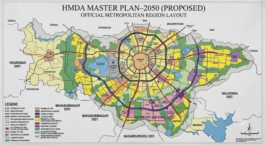
HMDA Master Plan 2050. This plan remains at the study stage. According to The Times of India, HMDA plans three sector studies covering mobility, economic development, and blue-green infrastructure, followed by a comprehensive plan. As of 23 May 2026, reports indicated that the preliminary planning documents had been drafted, while the tender for preparing the base map was still pending. Officials also indicated that the plan would become usable by 2027.
The draft Comprehensive Mobility Plan presented at a planning workshop in March 2026 outlined a proposed metro network spanning approximately 258.4 km by 2030, 534.1 km by 2040 and 556.6 km by 2050, with an estimated investment of around ₹4 lakh crore. These projections indicate the proposed scale and long-term infrastructure vision for the region’s mobility network.(Source)
Ratan Tata Road: Sanctioned Corridor, Not a Finished Commute
The Ratan Tata Road, also called the Greenfield Radial Road-1, forms the most concrete link between the city and Future City. It deserves careful reading, though.
| Detail | What the records show |
|---|---|
| Route | From ORR Exit 13 at Raviryal to the proposed Regional Ring Road at Amangal |
| Length and width | 41.5 km long and 100 m wide, with six lanes |
| Median | 20 m, reserved for a possible future metro or MMTS |
| Responsible agencies | HMDA and HGCL |
| Phases | Phase I covers 19.2 km and Phase II covers 22.3 km |
| Forest clearance | Stage-II forest clearance for 87.66 hectares, reported by The New Indian Express on 4 June 2026 |
| Contractors | Rithwik for Phase I and L&T for Phase II, as reported by Deccan Chronicle on 16 August 2026 |
The cost figures differ across sources. A government release reported by The Hindu put the total at ₹4,030 crore, with ₹1,665 crore for Phase I and ₹2,365 crore for Phase II. Later, Deccan Chronicle reported a revised figure of ₹4,621 crore in August 2026. Both figures come from press reports, so readers can treat the exact cost as still evolving.
Most importantly, the road remains under construction. A buyer cannot yet time a daily commute on it. Similarly, the 20 m median only reserves space for a possible metro, which does not mean a metro will run there.
The Regional Ring Road (RRR) follows the same logic. HMDA’s website shows a proposed 100m RRR alignment, roughly 354 km long. A proposed alignment, however, does not turn nearby farmland into residential land.
If You Are Looking at Land Inside FCDA
This section focuses purely on what any buyer can check. A useful rule sums it up: a government order that creates an authority is not a house.
Before paying a token for land described as “Future City,” a buyer can make four checks:
- Is the survey number in G.O.Ms.No.69? The second notification lists the villages, so the buyer can confirm the land actually falls within FCDA.
- Who approved the layout? For land transferred to FCDA, the layout approval should come from FCDA through BuildNow after March 2025. An older HMDA or DTCP approval may not carry over automatically.
- Has the land use changed legally? Agricultural, conservation, or lake-bed land needs a conversion order and receipt.
- Are there forest or legal issues? Some land faces environmental questions, and a petition before the National Green Tribunal has raised concerns about clearances. The forest clearance granted so far applies to the radial road, not to the whole FCDA area.
Land disputes and pending legal cases show why a zone color in a brochure cannot replace a proper title deed. A careful buyer also avoids paying extra simply because a future plan sounds promising.
Do’s
- Check the survey number against G.O.Ms.No.69
- Confirm the layout approval came from FCDA after March 2025
- Read hmda.gov.in for the live Master Plan 2031
- Treat the Ratan Tata Road as under construction
- Note both reported costs for the radial road
- Verify land use, conversion, and legal status
Don’ts
- Assume any land marketed as Future City falls within FCDA
- Rely on an older HMDA or DTCP approval for a transferred village
- Ask for a Master Plan 2050 zoning certificate that does not exist
- Plan a daily commute on a road still being built
- Pick one cost figure as final
- Pay extra because “2050 is coming”
Key Takeaways
- FCDA exists, created by G.O.Ms.No.69 on 12 March 2025 for 56 villages across about 765.28 sq km.
- G.O.Ms.No.68 expanded the HMDA region to about 10,472.723 sq km, but it did not create Master Plan 2050.
- HMDA’s live map remains Master Plan 2031, and Master Plan 2050 is still at the study stage.
- The Future City Master Plan–2047 is a separate process led by consultants.
- The Ratan Tata Road is a 41.5 km corridor under construction, not a finished commute.
- A proposed metro in the road’s median does not mean an operating line.
- Buyers can check the survey number, layout approval, land use, and legal status before paying.